Warnings
Winter Storm Warning
- Allen, KY
- Clinton, KY
- Cumberland, KY
- Logan, KY
- Monroe, KY
- Simpson, KY
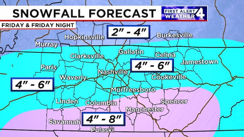
* WHAT...Heavy snow expected. Total snow accumulations of 3 to 6 inches are expected. Along the Kentucky and Tennessee border, 4 to 6 inches with locally higher amounts are expected. * WHERE...Portions of east central, north central, northwest, and south central Kentucky. * WHEN...From 3 AM CST /4 AM EST/ Friday to 6 AM CST /7 AM EST/ Saturday. * IMPACTS...Roads, and especially bridges and overpasses, will likely become slick and hazardous. The Friday afternoon commute will be negatively impacted.
- Calloway, KY
- Christian, KY
- Todd, KY
- Trigg, KY
* WHAT...Heavy snow expected. Total snow accumulations between 3 and 5 inches, with higher amounts possible near the Arkansas and Tennessee borders. * WHERE...All of southern Illinois, southwest Indiana, western Kentucky, and southeast Missouri. * WHEN...From midnight CST /1 AM EST/ tonight to midnight CST /1 AM EST/ Friday Night. * IMPACTS...Plan on slippery road conditions. The hazardous conditions could impact the Friday morning and evening commutes.
- Bedford, TN
- Cannon, TN
- Cheatham, TN
- Coffee, TN
- Davidson, TN
- DeKalb, TN
- Dickson, TN
- Giles, TN
- Grundy, TN
- Hickman, TN
- Houston, TN
- Humphreys, TN
- Lawrence, TN
- Lewis, TN
- Macon, TN
- Marshall, TN
- Maury, TN
- Montgomery, TN
- Perry, TN
- Robertson, TN
- Rutherford, TN
- Smith, TN
- Stewart, TN
- Sumner, TN
- Trousdale, TN
- Warren, TN
- Wayne, TN
- Williamson, TN
- Wilson, TN
* WHAT...Heavy snow expected. Total snow accumulations between 3 and 6 inches with locally higher amounts possible. * WHERE...Most of Middle Tennessee. * WHEN...From 3 AM Friday to 6 AM CST Saturday. * IMPACTS...Plan on slippery roads and difficult travel conditions. The hazardous conditions could impact the Friday morning and evening commutes.
- Benton, TN
- Carroll, TN
- Decatur, TN
- Hardin, TN
- Henderson, TN
- Henry, TN
* WHAT...Heavy snowfall expected. Total snow accumulations between 4 and 6 inches. * WHERE...Portions of East Arkansas, North Mississippi, Southeast Missouri, and West Tennessee. * WHEN...From 6 PM Thursday to 6 AM CST Saturday. * IMPACTS...Travel could be very difficult. The hazardous conditions could impact the Friday morning and evening commutes.
- Clay, TN
- Cumberland, TN
- Fentress, TN
- Jackson, TN
- Overton, TN
- Pickett, TN
- Putnam, TN
- Van Buren, TN
- White, TN
* WHAT...Heavy snow expected. Total snow accumulations between 3 and 6 inches with locally higher amounts possible. * WHERE...A portion of Middle Tennessee. * WHEN...From 9 AM Friday to 6 AM CST Saturday. * IMPACTS...Plan on slippery roads and difficult travel conditions. The hazardous conditions could impact the Friday morning and evening commutes.
- Franklin, TN
- Lincoln, TN
- Moore, TN
* WHAT...Heavy mixed precipitation expected Northern Alabama and Southern Middle Tennessee. Total snow and sleet accumulations between 2 and 4 inches and ice accumulations up to one tenth of an inch with locally higher amounts possible. * WHERE...Portions of north central, northeast, and northwest Alabama and southern middle Tennessee. * WHEN...From midnight tonight to 6 AM CST Saturday. * IMPACTS...Plan on slippery road conditions. The hazardous conditions could impact the Friday morning and evening commutes.
Watches
Winter Storm Watch
- Christian, KY
- Todd, KY
- Trigg, KY
The Winter Storm Watch has been replaced. Please see the latest information from NWS Paducah KY on this developing situation.